

Mapping for Architectural Site Analysis
Mapping for Architectural Site Analysis
Published 7/2025
Duration: 1h 18m | .MP4 1280x720 30 fps(r) | AAC, 44100 Hz, 2ch | 1.12 GB
Genre: eLearning | Language: English
Published 7/2025
Duration: 1h 18m | .MP4 1280x720 30 fps(r) | AAC, 44100 Hz, 2ch | 1.12 GB
Genre: eLearning | Language: English
Learn Architecture, Landscape Architecture, and Urban Design Mappings
What you'll learn
- Key Components of Mapping
- How to Extracting Layered Site Maps
- Multiple Mapping Styles and Its Variations (in Adobe Illustrator)
- Multiple Mapping Styles and Its Variations (in Adobe Photoshop)
Requirements
- Photoshop
Description
This course teaches essential mapping techniques for architecture, landscape architecture, and urban design. Learn how to extract data from open-source platforms, organize mapping layers, and create diverse site analysis diagrams. Through practical demonstrations, you’ll develop skills in visualizing site conditions, analyzing environmental factors, and enhancing your design presentations with effective mapping strategies.
About MeI’m a guest lecturer at top universities in the US, Canada and the UK, where I teach topics like architectural mapping, resilient design, and AI in landscape and architecture.
I’m also the author of the award-winning bookLandscape Architecture for Sea Level Rise: Innovative Global Solutions, which received the prestigious 2024 ASLA Professional Award, Architecture Book of the Year Awards by WAF, Best Book of Year 2022 by ASLA. My work focuses on climate resilience, GeoDesign, and innovative approaches to addressing environmental challenges.This tutorial is ideal for:
Architecture, landscape architecture, and urban design students
Professionals looking to enhance their site analysis techniques
Designers who want to create visually compelling mapping diagrams
Anyone interested in using mapping tools for environmental and spatial analysis
Online Lecture Table of Content
Introduction
What is Mapping
Key Components of Mapping
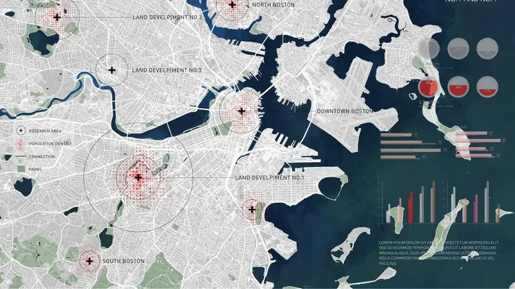
How to Extracting Layered Site Maps
Mapping Style 1 and Its Variations (OpenStreetMap to Adobe Illustrator)
Mapping Style 2 and Its Variations (OpenStreetMap to Photoshop, Axonomteric Diagram)
Mapping Style 3 and Its Variations (Mapbox to Photoshop, Large Scale Mapping)
Mapping Style 4 and Its Variations (Google Earth and CadMapper to Photoshop)
Who this course is for:
- Architecture students
- Landscape Architecture students
- Architects and Landscape Architects
- Urban Designers
More Info