

OkMap 13.1.1 Multilingual
OkMap 13.1.1 Multilingual | 41.4 MB
OkMap is an interactive software which allows you to work on your computer screen with digital maps that you have either bought or scanned. OkMap can also import vectorial data from the most common formats and DEM data relevant to height informations.
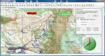
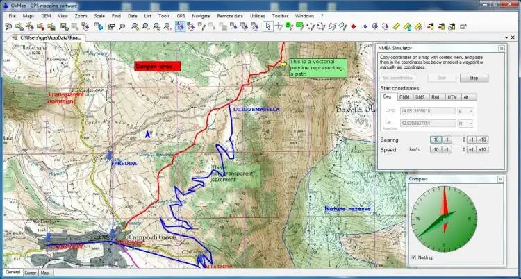
Through these maps, you can organize your paths by creating waypoints, routes and tracks on your computer monitor, and upload this data to your GPS. To make it easier, OkMap provides you also with autorouting and geocoding functions.
Data collected by your GPS can be downloaded on your computer, stored and displayed on the maps. They can also be used to create different types of statistics.
By connecting a GPS to your laptop, you can plot your position on maps in real-time. If you are connected to the network you can constantly send your position to a remote computer, or receive the position of your companions on your computer and display the related tracks on maps in real time.
OkMap can also interface Google Maps and Google Earth. With Google Maps you can get portions of maps immediately available in OkMap. With Google Earth you can view your paths and your maps also in 3D.
OkMap include a feature to generate automatically compatible "Garmin Custom Maps" (kmz format). This feature includes map tiling from and to different image file formats (including ECW map format). It’s possible select KML extensions 2.2 (if GPS supports them), the JPEG quality, the image resizing, the KML transparency, the draw order, and so on. You can also select the tiles to generate in output. This feature support "not north oriented" maps also.
OkMap 13.1.1 Multilingual

OkMap 13.1.1 Multilingual
OS : Windows XP / Vista / 7 / 8 / 10
Language : Multilingual
Home Page - http://www.okmap.org/