

Autodesk AutoCAD Map 3D 2026.0.1 with Offline help
Autodesk AutoCAD Map 3D 2026.0.1 with Offline help | 9.5 Gb
Languages Supported *: English, Português-Brasil, Čeština, Français, Deutsch, Magyar,
Italiano, 日本語, 한국어, Polski, Русский, 简体中文, Español, 繁體中文
Languages Supported *: English, Português-Brasil, Čeština, Français, Deutsch, Magyar,
Italiano, 日本語, 한국어, Polski, Русский, 简体中文, Español, 繁體中文
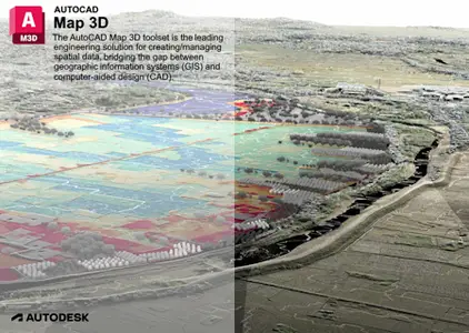
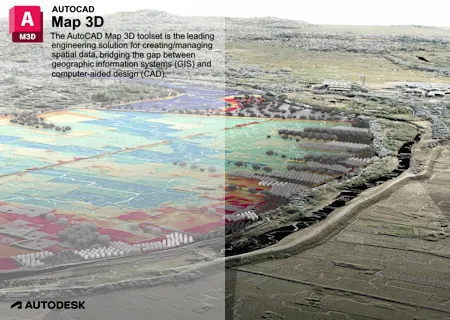
Autodesk has released AutoCAD Map 3D 2026.0.1 Toolset is model-based GIS mapping software that provides access to CAD and GIS data to support planning, design, and management.
What's New in AutoCAD Map 3D 2026.0 Toolset
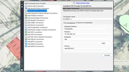
FDO ArcGIS Pro (What's New in 2026)
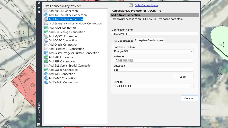
FDO ArcGIS Pro is a new FDO provider introduced in AutoCAD Map 3D 2026 toolset. This provider allows access to GIS data stored in a file geodatabase or an enterprise geodatabase such as Oracle, PostgreSQL, and SQL Server. After adding the data to the map, you can modify, analyze, and stylize it. Changes to feature attributes and geometry can be saved back to the data source.
![Autodesk AutoCAD Map 3D 2026.0.1 with Offline help]()
Note:
- ArcGIS Pro must be installed and licensed on the same machine as AutoCAD Map 3D toolset.
- The ArcGIS Pro provider uses the ESRI ArcGIS Pro SDK 3.3.
The addition of the FDO ArcGIS Pro provider enhances the capabilities of the AutoCAD Map 3D toolset in handling GIS data.
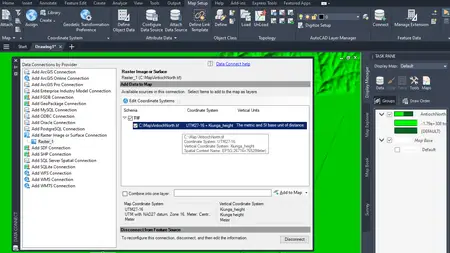
Vertical Coordinate System Support in FDO Raster (What's New in 2026)
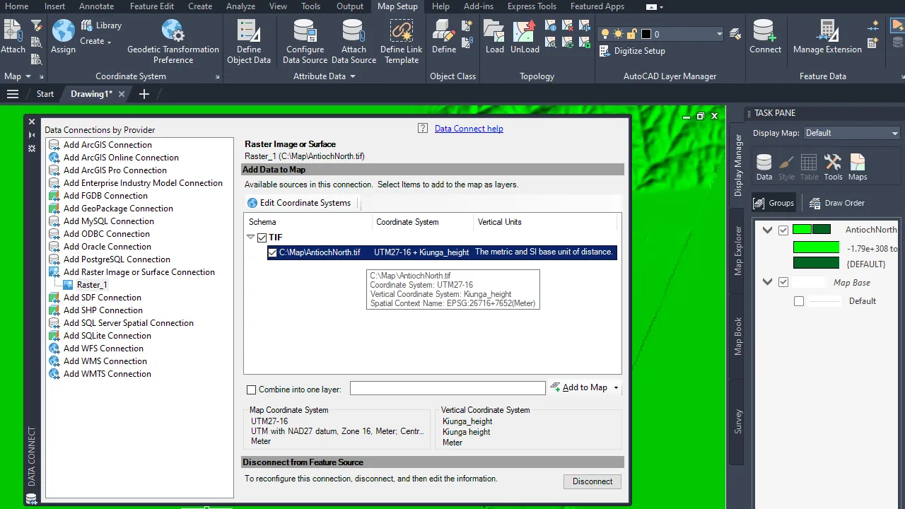
FDO Raster in AutoCAD Map 3D 2026 current offers support for vertical coordinate systems as a tech preview. When a raster file has a vertical coordinate system and the MAPVERTICALCSENABLED system variable is set to 1, AutoCAD Map 3D 2026 displays both the horizontal coordinate system (HCS) and the vertical coordinate system (VCS) in the feature class list in the Data Connect dialog box. You can choose to override the coordinate system if necessary. Once the data is added to the map, the drawing’s coordinate system in the status bar reflects both HCS and VCS. In the drawing, use the GEOCSASSIGN command to change the HCS or VCS, which then initiates the coordinate system transformation.
![Autodesk AutoCAD Map 3D 2026.0.1 with Offline help]()
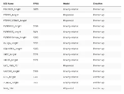
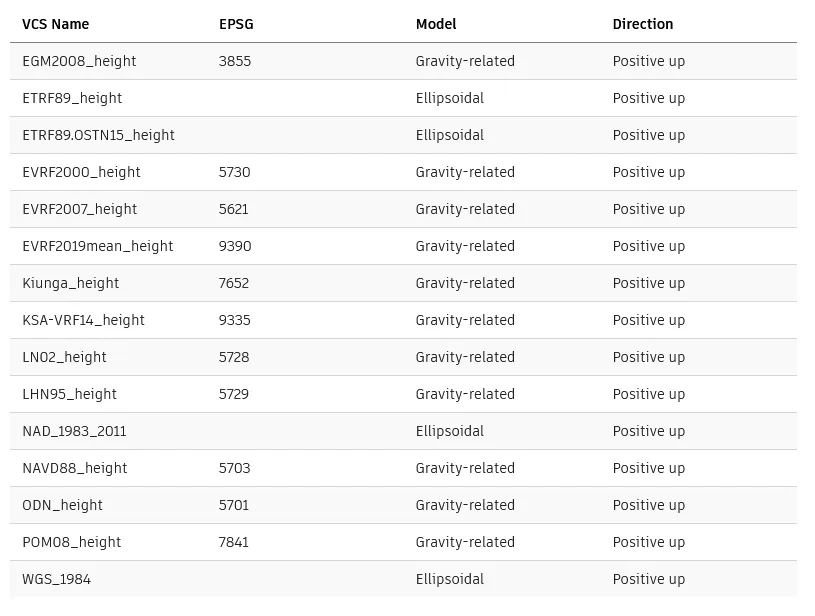
The table below displays a list of supported vertical coordinate systems.
![Autodesk AutoCAD Map 3D 2026.0.1 with Offline help]()
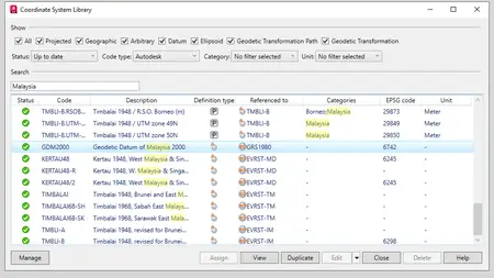
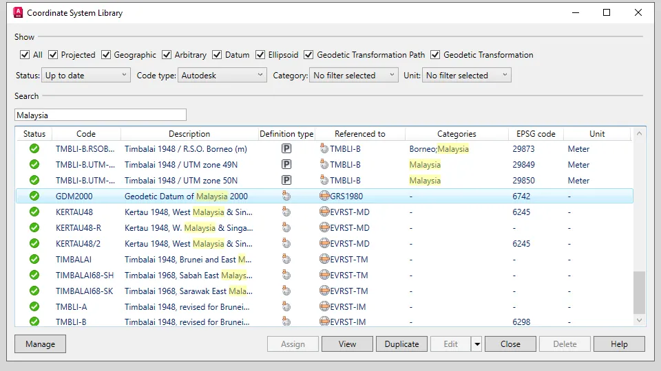
Coordinate System Update (What's New in 2026)
AutoCAD Map 3D 2026 includes the following updates related to the coordinate system:
- New horizontal coordinate systems
. UK Rail Coordinate Systems
. Malaysia 2000 Coordinate Systems
. Saudi Arabia EPSG 20439
- New first-class vertical coordinate systems
. Vertical transformation between ETRS89 and ODN
. Coordinate Systems ETRF89.OSTN15_height
. Switzerland Vertical Coordinate Systems
.. EPSG code: 5728, 5729
- Updates to coordinate system definitions
. Correction of the EPSG code for the CzechJTSK/5b.Krovak Coordinate System
. Fixes for name mapping issues with datum MGI-1901/Kos
. Updates to Serbia Coordinate Systems
. Correction of the EPSG code for Autodesk AinElAbd.UTM-39N
. Addition of the ESRI WKT string for EPSG 6751 Coordinate System
. Correction of coordinate system information for AinElAbd.UTM-39N
. Correction of the coordinate system boundary for Jackson County, MN
![Autodesk AutoCAD Map 3D 2026.0.1 with Offline help]()
Quality improvements
- AutoCAD Map 3D 2026 now allows working with drawings and FDO data sources in Autodesk Docs. To access Autodesk Docs, install Autodesk Desktop Connector. Save drawings with FDO connections to any file format from an Autodesk Docs folder, such as SHP, SDF, SQLite, or raster data, in Autodesk Docs. Then, open them from any local machine with all FDO connections intact.
- Extended support for the following FDO providers to newer versions:
. FDO PostGIS: PostgreSQL 16.4 / PostGIS 3.4
. FDO MySQL: MySQL 8.4
- The Display Manager (Draw Order tab) now allows adjusting the layer order using new shortcut menu options: Move to Top and Move to Bottom.
- The form of an industry model feature class now includes the Use the current record as Reference option when creating a new reference record. If selected, this option allows specifying the reference attributes to be included.
- AutoCAD Map 3D now provides more informative messages when editing attributes on the form if there are errors in the inputs.
- The Save Current Map to AutoCAD dialog box (MAPTOACAD command) now includes options to select the method for converting line style thickness (MAPTOACADUSELINEWEIGHT system variable).
- When loading a layer containing an expression error or layer definition errors in AutoCAD Map 3D, the Display Manager displays the layer error icon. It also shows the corresponding error tooltip prompts. The same behavior occurs when opening a layer with these errors in an industry model.
The following customer issues have been resolved in AutoCAD Map 3D 2026 toolset.
- Annotation: AutoCAD Map 3D no longer crashes when deleting multileader annotations.
- FDO WMTS: Fixed connection and display issues for some WMTS.
- FDO WMS
. The Data Connect dialog box now includes a new Choose coordinate system option in the Server CS code drop-down list, allowing selection of a different coordinate system from the CS library.
. Fixed data connection problems for some WMS.
- FDO WFS: Fixed connection and display issues for some WFS.
- FDO PostgreSQL: AutoCAD polylines now correctly convert to line features and save to the PostgreSQL database.
- FDO Raster: ECW raster images now display correctly after being added to the map.
- Layout and Viewports: For drawings with multiple layouts whose viewports are connected to a north arrow, AutoCAD Map 3D now keeps all viewports connected to the dynamic north arrow when executing some commands and reopening the drawing.
- MAPTOACAD Command
. The MAPTOACAD command no longer crashes when working with drawings that have symbols in different layers with the same name, color, and size.
. The MAPTOACAD command now displays the correct color in the results for specific industry model drawings.
. For drawings containing FDO Raster connections, the MAPTOACAD command now works as expected.
- MAPCREATECENTROIDS Command: The MAPCREATECENTROIDS command now works as expected.
- MAPFEATURESPLIT Command: The MAPFEATURESPLIT command now correctly splits polygon features with Z dimensions from SHP files.
- Import and Export: AutoCAD Map 3D no longer crashes when exporting objects to Esri Shapefile or Google KML/KMZ file format for a drawing with a user-defined coordinate system.
- Industry Models
. AutoCAD Map 3D no longer crashes when digitizing pipe areas in electric models.
. AutoCAD Map 3D no longer crashes when selecting more than one polygon as the job perimeter for industry models on Oracle 19c.
. AutoCAD Infrastructure Administrator no longer crashes when creating a new job template for projects with specific industry model settings.
. AutoCAD Map 3D now strictly complies with the settings defined in Infrastructure Administrator regarding creating or not creating a label.
. AutoCAD Map 3D now shows values with the correct decimals for number attributes.
. For file-based industry models with EPSG:31370 coordinate system, creating new features no longer results in offsets to the selected locations.
. Topology connections are no longer broken after importing new objects with the Validate after conversion option enabled in the Convert to Industry Model dialog box (MAPCONVERTTOMODEL command).
. OSNAP works as expected with large data from a view layer in the industry model.
. Print preview and plot now work as expected when the drawing contains complex polygons.
. Actions in forms can now be triggered with a click.
. Export to Excel works as expected when the form contains a filter.
. Clearing the history of conflicting features now works as expected.
FDO ArcGIS Pro is a new FDO provider introduced in AutoCAD Map 3D 2026 toolset. This provider allows access to GIS data stored in a file geodatabase or an enterprise geodatabase such as Oracle, PostgreSQL, and SQL Server. After adding the data to the map, you can modify, analyze, and stylize it. Changes to feature attributes and geometry can be saved back to the data source.
Autodesk AutoCAD Map 3D 2026.0.1 with Offline help
Note:
- ArcGIS Pro must be installed and licensed on the same machine as AutoCAD Map 3D toolset.
- The ArcGIS Pro provider uses the ESRI ArcGIS Pro SDK 3.3.
The addition of the FDO ArcGIS Pro provider enhances the capabilities of the AutoCAD Map 3D toolset in handling GIS data.
Vertical Coordinate System Support in FDO Raster (What's New in 2026)
FDO Raster in AutoCAD Map 3D 2026 current offers support for vertical coordinate systems as a tech preview. When a raster file has a vertical coordinate system and the MAPVERTICALCSENABLED system variable is set to 1, AutoCAD Map 3D 2026 displays both the horizontal coordinate system (HCS) and the vertical coordinate system (VCS) in the feature class list in the Data Connect dialog box. You can choose to override the coordinate system if necessary. Once the data is added to the map, the drawing’s coordinate system in the status bar reflects both HCS and VCS. In the drawing, use the GEOCSASSIGN command to change the HCS or VCS, which then initiates the coordinate system transformation.
Autodesk AutoCAD Map 3D 2026.0.1 with Offline help
The table below displays a list of supported vertical coordinate systems.
Autodesk AutoCAD Map 3D 2026.0.1 with Offline help
Coordinate System Update (What's New in 2026)
AutoCAD Map 3D 2026 includes the following updates related to the coordinate system:
- New horizontal coordinate systems
. UK Rail Coordinate Systems
. Malaysia 2000 Coordinate Systems
. Saudi Arabia EPSG 20439
- New first-class vertical coordinate systems
. Vertical transformation between ETRS89 and ODN
. Coordinate Systems ETRF89.OSTN15_height
. Switzerland Vertical Coordinate Systems
.. EPSG code: 5728, 5729
- Updates to coordinate system definitions
. Correction of the EPSG code for the CzechJTSK/5b.Krovak Coordinate System
. Fixes for name mapping issues with datum MGI-1901/Kos
. Updates to Serbia Coordinate Systems
. Correction of the EPSG code for Autodesk AinElAbd.UTM-39N
. Addition of the ESRI WKT string for EPSG 6751 Coordinate System
. Correction of coordinate system information for AinElAbd.UTM-39N
. Correction of the coordinate system boundary for Jackson County, MN
Autodesk AutoCAD Map 3D 2026.0.1 with Offline help
Quality improvements
- AutoCAD Map 3D 2026 now allows working with drawings and FDO data sources in Autodesk Docs. To access Autodesk Docs, install Autodesk Desktop Connector. Save drawings with FDO connections to any file format from an Autodesk Docs folder, such as SHP, SDF, SQLite, or raster data, in Autodesk Docs. Then, open them from any local machine with all FDO connections intact.
- Extended support for the following FDO providers to newer versions:
. FDO PostGIS: PostgreSQL 16.4 / PostGIS 3.4
. FDO MySQL: MySQL 8.4
- The Display Manager (Draw Order tab) now allows adjusting the layer order using new shortcut menu options: Move to Top and Move to Bottom.
- The form of an industry model feature class now includes the Use the current record as Reference option when creating a new reference record. If selected, this option allows specifying the reference attributes to be included.
- AutoCAD Map 3D now provides more informative messages when editing attributes on the form if there are errors in the inputs.
- The Save Current Map to AutoCAD dialog box (MAPTOACAD command) now includes options to select the method for converting line style thickness (MAPTOACADUSELINEWEIGHT system variable).
- When loading a layer containing an expression error or layer definition errors in AutoCAD Map 3D, the Display Manager displays the layer error icon. It also shows the corresponding error tooltip prompts. The same behavior occurs when opening a layer with these errors in an industry model.
The following customer issues have been resolved in AutoCAD Map 3D 2026 toolset.
- Annotation: AutoCAD Map 3D no longer crashes when deleting multileader annotations.
- FDO WMTS: Fixed connection and display issues for some WMTS.
- FDO WMS
. The Data Connect dialog box now includes a new Choose coordinate system option in the Server CS code drop-down list, allowing selection of a different coordinate system from the CS library.
. Fixed data connection problems for some WMS.
- FDO WFS: Fixed connection and display issues for some WFS.
- FDO PostgreSQL: AutoCAD polylines now correctly convert to line features and save to the PostgreSQL database.
- FDO Raster: ECW raster images now display correctly after being added to the map.
- Layout and Viewports: For drawings with multiple layouts whose viewports are connected to a north arrow, AutoCAD Map 3D now keeps all viewports connected to the dynamic north arrow when executing some commands and reopening the drawing.
- MAPTOACAD Command
. The MAPTOACAD command no longer crashes when working with drawings that have symbols in different layers with the same name, color, and size.
. The MAPTOACAD command now displays the correct color in the results for specific industry model drawings.
. For drawings containing FDO Raster connections, the MAPTOACAD command now works as expected.
- MAPCREATECENTROIDS Command: The MAPCREATECENTROIDS command now works as expected.
- MAPFEATURESPLIT Command: The MAPFEATURESPLIT command now correctly splits polygon features with Z dimensions from SHP files.
- Import and Export: AutoCAD Map 3D no longer crashes when exporting objects to Esri Shapefile or Google KML/KMZ file format for a drawing with a user-defined coordinate system.
- Industry Models
. AutoCAD Map 3D no longer crashes when digitizing pipe areas in electric models.
. AutoCAD Map 3D no longer crashes when selecting more than one polygon as the job perimeter for industry models on Oracle 19c.
. AutoCAD Infrastructure Administrator no longer crashes when creating a new job template for projects with specific industry model settings.
. AutoCAD Map 3D now strictly complies with the settings defined in Infrastructure Administrator regarding creating or not creating a label.
. AutoCAD Map 3D now shows values with the correct decimals for number attributes.
. For file-based industry models with EPSG:31370 coordinate system, creating new features no longer results in offsets to the selected locations.
. Topology connections are no longer broken after importing new objects with the Validate after conversion option enabled in the Convert to Industry Model dialog box (MAPCONVERTTOMODEL command).
. OSNAP works as expected with large data from a view layer in the industry model.
. Print preview and plot now work as expected when the drawing contains complex polygons.
. Actions in forms can now be triggered with a click.
. Export to Excel works as expected when the form contains a filter.
. Clearing the history of conflicting features now works as expected.
Fixed Issues in AutoCAD Map 3D 2026.0.1 Update - Date: May 6, 2025
General Update Content
The following defects have been fixed:
Security Update
Improved stability with security updates for Map 3D and third-party components.
FDO Providers
AutoCAD Map 3D no longer crashes when opening drawings that contain WMTS, WMS, and WFS connections with lengthy URLs.
Stylization
The MAPSYMBOLIMPORTEXPORT command no longer changes the layer names which contain special characters.
Industry Models
AutoCAD Map 3D no longer crashes when generating graphics with a saved display model that contains a custom FDO provider.
Autodesk AutoCAD is computer-aided design software that allows you to efficiently create and document 2D and 3D designs. Industry-specific Autodesk tools, such as architecture, plant 3D, map 3D, MEP, electrical, mechanical and grid design, make Autodesk AutoCAD the number one software for architects, engineers and construction professionals.
Introduction to AutoCAD Map 3D - Everything Happens Somewhere
Autodesk helps people imagine, design and create a better world. Everyone—from design professionals, engineers and architects to digital artists, students and hobbyists—uses Autodesk software to unlock their creativity and solve important challenges.
Owner: Autodesk Inc.
Product Name: AutoCAD Map 3D Toolset
Version: 2026.0.1 with Offline Help *
Supported Architectures: x64
Website Home Page : www.autodesk.com
Languages Supported: multilanguage *
System Requirements: Windows **
Size: 9.5 Gb
AutoCAD_Map_2026_English_Win_64bit_dlm_001_002.sfx.exe
AutoCAD_Map_2026_English_Win_64bit_dlm_002_002.sfx.exe
AutoCAD_Map_3D_2026.0.1_Update.exe
Offline_Help_for_AutoCAD_Map3D_2026_Brazilian_Portuguese.exe
Offline_Help_for_AutoCAD_Map3D_2026_Czech.exe
Offline_Help_for_AutoCAD_Map3D_2026_English.exe
Offline_Help_for_AutoCAD_Map3D_2026_French.exe
Offline_Help_for_AutoCAD_Map3D_2026_German.exe
Offline_Help_for_AutoCAD_Map3D_2026_Hungarian.exe
Offline_Help_for_AutoCAD_Map3D_2026_Italian.exe
Offline_Help_for_AutoCAD_Map3D_2026_Japanese.exe
Offline_Help_for_AutoCAD_Map3D_2026_Korean.exe
Offline_Help_for_AutoCAD_Map3D_2026_Polish.exe
Offline_Help_for_AutoCAD_Map3D_2026_Russian.exe
Offline_Help_for_AutoCAD_Map3D_2026_Simplified_Chinese.exe
Offline_Help_for_AutoCAD_Map3D_2026_Spanish.exe
Offline_Help_for_AutoCAD_Map3D_2026_Traditional_Chinese.exe

Autodesk AutoCAD Map 3D 2026.0.1 with Offline help
Please visit my blog
Added by 3% of the overall size of the archive of information for the restoration
No mirrors please

![Autodesk AutoCAD Map 3D 2026.0.1 with Offline help]()
Added by 3% of the overall size of the archive of information for the restoration
No mirrors please
Autodesk AutoCAD Map 3D 2026.0.1 with Offline help
